Nashville Hit 100°F in Mid-September as the Largest Heat Dome on Earth Baked the Mid-South
Nashville broke a September record that had stood since 1927. But the number that will last is in Memphis, which just logged the hottest September day in its history — and across the Mid-South, the nights refused to cool off.
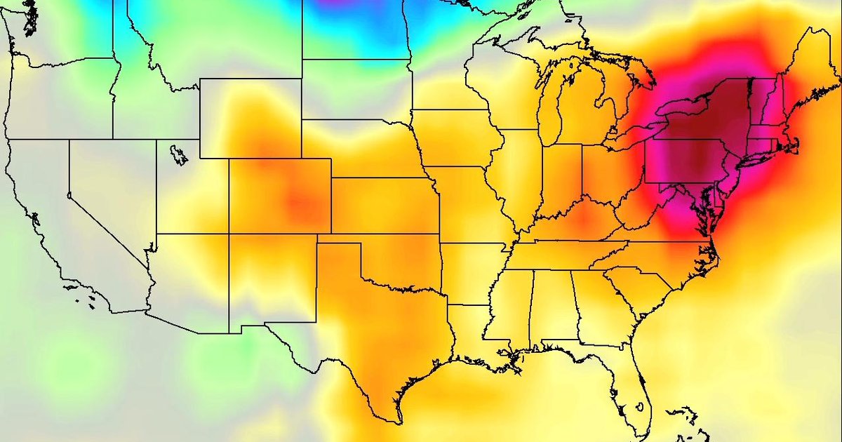
Nashville reached 100°F on September 15, 2026, breaking the city's September 15 record high of 98°F — a mark that had stood since 1927 — and it was only the second-latest 100°F reading in Nashville's history, per Nashville's NewsChannel 5. That was the headline. But when we pulled 56 years of NOAA station data for the cities under the dome, a bigger number turned up two states over.
Memphis hit 102.9°F on September 6, 2026 — the hottest September day in its recorded history (NOAA GHCN-Daily, 1970–2026). And the record that almost nobody reports fell hardest of all: of the eight Mid-South and Ohio Valley cities we analyzed, 7 set or tied their all-time September record-high overnight low — the warmest September night ever measured. The heat dome didn't just crank the afternoons; it stopped the nights from cooling.
The dome itself was historic. The Washington Post called it a record heat dome that “didn't get the memo” about fall, and mid-September reporting described it as the largest heat dome on Earth at the time — larger than the one over the Sahara — centered over Tennessee. NASA Earth Observatory mapped its footprint: on September 15, more than 41 million people — about 12% of the US population — were under a National Weather Service extreme heat advisory across Texas, Oklahoma, Arkansas, Missouri and Tennessee. Our live heat-advisory tracker still shows advisories active across nine states.
A July-grade heat dome, three weeks into September
Heat domes are a summer story. This one arrived as the calendar was turning to fall, which is why it broke so many records — the atmosphere was delivering mid-July heat against mid-September benchmarks that were set for a cooler time of year. NASA Earth Observatory's temperature map for 4 p.m. Central on September 15 showed the darkest reds — areas that approached or exceeded 40°C (104°F) — stretched across Texas, Oklahoma, Arkansas, Missouri and Tennessee.
It capped a summer that was already the hottest on record. Per NOAA, the June–August 2026 period was the warmest for the contiguous US in the agency's 132-year record — 0.4°F above the previous marks of 1936 and 2021. Against that backdrop, a strong ridge sinking hot, humid Gulf air over the Tennessee Valley didn't need to be a freak event to smash the book. It just had to hold. And it held for the better part of two weeks, which is what our station data captures below.
September 2026, City by City: The First 13 Days vs. the Record Book
The hottest September 2026 day at each city's primary NOAA airport station (through September 13, our archive cutoff), the number of days at or above 90°F and 100°F in those first 13 days, the hottest September day on record (1970–2026), and how many 90°F September days a normal year brings. Sorted by the 2026 peak.
| City | 2026 peak | Date | Days ≥90° | Days ≥100° | Hottest Sept ever | Normal 90° days/Sept |
|---|---|---|---|---|---|---|
| Memphis, TN | 102.9° | Sept 6 | 13 of 13 | 6 | 102.9° (2026) | 7.8 |
| Chattanooga, TN | 100.9° | Sept 4 | 11 of 13 | 4 | 102.9° (2019) | 4.4 |
| St. Louis, MO | 100.9° | Sept 5 | 8 of 13 | 4 | 104° (2011) | 4.1 |
| Nashville, TN | 100.9° | Sept 5 | 13 of 13 | 3 | 102° (1990) | 5.3 |
| Little Rock, AR | 100.9° | Sept 6 | 12 of 13 | 2 | 104° (2000) | 8.8 |
| Paducah, KY | 100° | Sept 5 | 10 of 13 | 1 | 100.9° (2022) | 4.5 |
| Louisville, KY | 100° | Sept 4 | 8 of 13 | 1 | 102° (2011) | 3.6 |
| Knoxville, TN | 98° | Sept 4 | 9 of 13 | 0 | 98° (2011) | 2.7 |
Source: NOAA NCEI GHCN-Daily via our records database, 1970–2026. “Normal” is the 1970–2025 average number of September days reaching 90°F. September 2026 counts cover the first 13 days only (observations complete through Sept 13); the eight cities combined logged 21 days at or above 100°F in that span. NWS keeps longer books than our 1970-onward archive for these cities, so a “hottest on record” here means since 1970.
Memphis just had the hottest September day in its record
Nashville got the coverage, but Memphis got the record. On September 6, 2026, Memphis International reached 102.9°F — the highest temperature ever recorded there in September in our 1970–2026 archive. It was the middle of a stretch that put Memphis at 100°F or hotter on six of the first 13 days of the month, more triple-digit September days than the city normally sees in a decade. A typical September there brings about eight days that even reach 90°F.
The pattern repeats down the table. Chattanooga (100.9°F, Sept 4) and St. Louis (100.9°F, Sept 5) each ran four 100°F days in the first two weeks; Little Rock hit 100.9°F on September 6 on its way to twelve 90°F days out of thirteen. These aren't marginal readings against the all-time September highs — Little Rock's 104°F from Labor Day 2000 and St. Louis's 104°F from 2011 still stand — but the sheer number of hot days, stacked back to back into mid-month, is what made this event unusual. It was less a spike than a siege.
This is the same heat regime that produced the Labor Day 2026 heat wave a week and a half earlier, when 11 Plains and Mid-South cities broke or tied a daily record. The ridge eased, then rebuilt — and the second act reached further east, straight over Nashville and the Tennessee Valley.
The Record That Fell Hardest: The Warmest September Nights on Record
Afternoon highs get the headlines; overnight lows tell the climate story. Here is each city's warmest September night of 2026 against its all-time September record-high minimum (the warmest overnight low ever recorded in September, 1970–2026). New = 2026 set a new record; Tie = it matched the record. Sorted by the 2026 low.
| City | Warmest 2026 night | Date | Sept record-high low | Status |
|---|---|---|---|---|
| Memphis, TN | 78.9° | Sept 5 | 78.9° (2008) | Tied |
| St. Louis, MO | 78.9° | Sept 1 | 78.9° (2026) | New record |
| Little Rock, AR | 78° | Sept 6 | 78° (1998) | Tied |
| Louisville, KY | 78° | Sept 4 | 78° (2026) | New record |
| Nashville, TN | 75.9° | Sept 4 | 75.9° (2012) | Tied |
| Chattanooga, TN | 75.9° | Sept 5 | 75.9° (2026) | New record |
| Paducah, KY | 75° | Sept 9 | 77° (1980) | — |
| Knoxville, TN | 75° | Sept 5 | 75° (2026) | New record |
Source: NOAA NCEI GHCN-Daily via our records database, 1970–2026. Record-high minimum = the warmest overnight low ever recorded in September at that station. Paducah's warmest 2026 night (75°F) stayed below its 77°F September record from 1980.
Why the warm nights are the real signal
A hot afternoon can come from a single sunny, dry day. A record-warm night is harder to make: it takes humidity, cloud cover or trapped heat that keeps the surface from radiating away its warmth after dark. That is why overnight-low records are the cleaner fingerprint of a warming, moister climate — and why 7 of these eight cities setting or tying their warmest-ever September night matters more than any one afternoon high. Knoxville (75°F), Chattanooga (75.9°F), Louisville (78°F) and St. Louis (78.9°F) posted new September marks; Nashville, Memphis and Little Rock tied theirs.
Warm nights are also the dangerous part of a heat wave. Without a nighttime break, bodies — and buildings without air conditioning — never get to recover, which is why the NWS issues heat advisories on the combination of daytime heat index and overnight lows, not the afternoon number alone. The same long-term shift shows up in our city-by-city summer-warming analysis and the running tally of a record-warm 2026.
How we measured this
Every temperature in our tables is the official daily high or low from that city's primary long-record airport station, pulled from NOAA's GHCN-Daily archive. Our continuous daily record begins in 1970, so “on record” here means since 1970; the National Weather Service keeps longer books for most of these cities, back to the 1870s in some cases, so a reading that set a record in our archive may sit under an older NWS mark. Our September 2026 observations were complete through September 13 when we queried the archive on September 18. The September 15 peak readings — Nashville's 100°F and 1927 record, Memphis's 99°F and Dallas's 101°F — postdate our archive cutoff and are cited to NASA Earth Observatory and Nashville-market reporting, not to our database.
Frequently Asked Questions
How hot did Nashville get in September 2026?▾
Nashville reached 100°F on September 15, 2026, breaking the September 15 record high of 98°F set in 1927, according to NASA Earth Observatory and Nashville-market reporting. It was only the second-latest 100°F reading in Nashville history. In our NOAA archive, every one of the first 13 days of September 2026 hit at least 90°F at Nashville International — a normal September there averages about five 90°F days for the entire month — and three of those days topped 100°F.
Was this Memphis’s hottest September day on record?▾
Yes. Memphis International hit 102.9°F on September 6, 2026 — the hottest September day in its continuous NOAA record, which begins in 1970. It edged past the previous September benchmarks and gave Memphis six days at or above 100°F in the first 13 days of the month, against a normal of roughly eight 90°F days for the whole of September.
Why was it so hot in Tennessee in September 2026?▾
A heat dome — a strong upper-level ridge of high pressure that traps sinking, compressing air beneath clear skies — parked over the south-central US. Mid-September reporting described it as the largest heat dome on Earth at the time, centered over Tennessee, and the Washington Post called it a record heat dome. NASA Earth Observatory mapped its footprint: on September 15, more than 41 million people (about 12% of the US population) were under a National Weather Service extreme heat advisory across Texas, Oklahoma, Arkansas, Missouri and Tennessee.
Did the heat break overnight-low records too?▾
That was the sharper record. Of the eight Mid-South cities we analyzed, seven set or tied their all-time September record-high minimum — the warmest overnight low ever recorded in September. Knoxville (75°F), Chattanooga (75.9°F), Louisville (78°F) and St. Louis (78.9°F) set new September marks in 2026; Nashville (75.9°F), Memphis (78.9°F) and Little Rock (78°F) tied theirs. Warmer nights are the clearest fingerprint of a warming climate because they reflect humidity and trapped heat, not just afternoon sun.
How does September 2026 compare to a normal September?▾
It ran far hotter. Across the 1970–2025 record, a normal September brings roughly three 90°F days in Knoxville, four to five in Nashville, Chattanooga and Louisville, and eight in Little Rock and Memphis. In just the first 13 days of September 2026, Nashville and Memphis each recorded thirteen 90°F days, Little Rock twelve, and the eight cities combined logged 21 days at or above 100°F. Summer 2026 (June–August) was already the warmest on record for the contiguous US in NOAA’s 132-year dataset, 0.4°F above the previous records of 1936 and 2021.
Related Analysis
- Live: Heat Advisories Active Across Nine States
- Labor Day 2026 Heat Wave: Every Record It Broke, by City
- The Worst Heat Waves in US History
- 2026: On Track to Be the Hottest Year on Record
- The Cities Where Summer Has Warmed Most Since 1990
- Tennessee Weather Records & Extremes
- Nashville Weather History & Records
- Memphis Weather History & Records
Curious how this heat compares where you live? Our historical weather lookup returns the daily high and low for any US ZIP code back to 1970 — enter a September date and see how 2026 stacks up against your own town's record book.